
mapping police patrols in Madison, WI
August 24th, 2015. Filed under: policing, research, writing.In an open letter to the Madison Police Chief, YGB recognizes the role of policing practices in producing these disparities, citing reports that show Black people in the county are eight times more likely to be arrested than whites (this number is probably closer to eleven in the city of Madison). In response, they call for self-determination and an end to interactions with the police. In his patronizing response, Madison Police Chief Koval instead vows to increase police presence in neighborhoods of color, denying the role of policing practices in producing and/or upholding the city’s longstanding disparities. Similarly, Mayor Soglin has dismissed such critiques, saying racial bias in policing is “the wrong question to be asked,” instead deferring blame onto “the entire criminal justice system.”
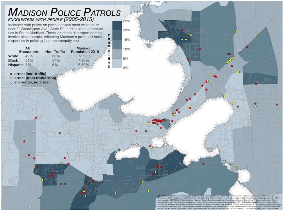
With these divergent views on policing in mind, I began searching through police incident reports to see if they would reveal spatial or racial patterns of policing. I was particularly interested in revealing police patrol patterns to substantiate claims made by YGB and others that communities of color are over-policed. Patrol patterns are not made public by the city, but as others have observed, the presence of police in affluent Madison neighborhoods is minimal. To gather the data, I first keyword searched and then read police incident reports to determine incidents that happened while an officer was on patrol, not precipitated by a service call. I then searched court records to determine the race of those arrested (only cases that went to trial showed up on this search, which accounted for about 75% of incidents) and mapped the results. I found that arrests were clustered on the busy East Washington Avenue that traverses the isthmus, the bar and restaurant-filled State Street that connects campus with the Capitol building, and three communities in South Madison with high Black populations. I also found profound racial disparities in who was targeted and arrested in patrol stops, mirroring the findings in the Race to Equity report.
click to enlarge
Of course, there are limitations to this map. First, it is based on a limited amount of data, in large part because incident reports do not necessarily indicate when an officer was on patrol. Only through keyword searches and close readings was I able to build this database. Second, incidents only enter the city database if they are deemed to have “significant public interest.” The criteria for this categorization, as far as I am aware, is not made explicit by the city. Third, many incidents involved multiple people, which is not represented on this map. And last, I have not yet attempted to map the spatial distribution of the race of those involved, which may reveal other patterns. Despite these limitations, the map does reveal patterns that substantiate claims of uneven policing across the city.

October 5th, 2015 at 11:25 am
[…] as I argued in an earlier post, the practices of patrolling officers seem to reflect those same disparities (although, the role of […]